6.3. 3DCityDB @ virtualcitySYSTEMS
virtualcitySYSTEMS has successfully applied the 3D City Database in customer projects worldwide and also funded its development. With the Open Source database at the core, virtualcitySYSTEMS also offers a 3D Spatial Data Infrastructure solution for the management, distribution, maintenance and visualization of massive 3D geo data (see next page). As leading developers of the 3D City Database joined the company, virtualcitySYSTEMS now takes an active role in its development. Moreover, virtualcitySYSTEMS offers a branded version of the 3D City database called the virtualcityDATABASE to answer customer demands and to provide support and maintenance.
6.3.1. virtualcityDATABASE
The virtualcityDATABASE provides enhanced database functionality as well as plugins for the Importer/Exporter tool that support workflows for maintaining and updating the 3D city model content. Main features are:
- Integration of additional LoDs against existing city objects in the databaseThis plugin allows for integrating city objects from an external data source with existing city objects stored in the database. The candidate objects are identified with the database objects based on thematic and spatial checks. Therefore, data inconsistency can easily be spotted and analyzed before an import. If an integration is performed, exiting LoDs are replaced and newly introduced LoDs are attached to the existing objects. Moreover, appearance information can be integrated without replacing the geometry.
- Deletion of entire city objects or single LoDs representationsThe 3D City Database provides a low-level API for deleting city objects. This API has been extended in the virtualcityDATABASE to also delete single LoDs of city objects. A graphical user dialog realized as a plugin for the Importer/Exporter allows users to easily delete city objects based on comprehensive thematic filter criteria.
- Adding material appearances for buildingsThis plugin helps to define constant material information for building surfaces based on thematic properties (e.g., to colorize roofs according to their solar potential).
- Transactional Web Feature ServiceCustomers of the virtualcityDATABASE already benefit from an OGC-compliant WFS 2.0 implementation that supports transactions as well as comprehensive spatial and thematic queries using the OGC Filter Encoding standard.
The virtualcityDATABASE is fully compliant with the 3D City Database. If features developed for the virtualcityDATABASE have gained enough maturity, virtualcitySYSTEMS will introduce them to the Open Source 3D City Database project (e.g. the WFS interface).
6.3.2. virtualcitySUITE – The 3D City Platform
The virtualcitySUITE is a modular 3D Spatial Data Infrastructure solution to store, manage, distribute and visualize 3D geo data. Core components are the virtualcityDATABASE and its OGC WFS interface for accessing and editing the data, the virtualcityWAREHOUSE, a data distribution solution running on FME technology that enables users to export 3D city model content from the virtualcityDATABASE into various industry GIS and CAD formats, and the web-based authoring tool virtualcityPUBLISHER for creating high-performance 3D web maps. Based on the Open Source 3D City Database, the virtualcitySUITE allows for building a 3D SDI platform for virtual 3D city models based on open standards and interfaces.
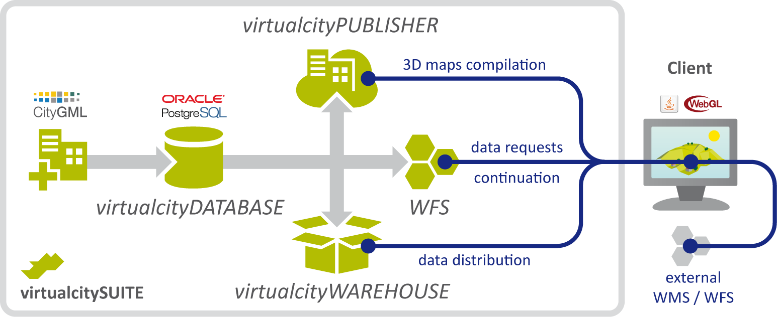
Fig. 6.1 Components of the virtualcitySUITE.
Our 3D web maps offer enhanced GIS functionality beyond pure 3D visualization including 3D measurements, real-time shadows, WFS-based thematic and spatial queries, POI integration, data exports through a virtualcityWAREHOUSE interface, and integration of external WMS and WFS data sources as well as pointcloud data and oblique imagery. The 3D web maps are based on the Cesium WebGL virtual globe and therefore can be displayed on modern web browsers and mobile devices such as tablets and smartphones without the need for additional plugins.
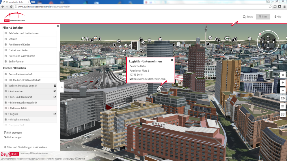
Fig. 6.2 The Berlin 3D City Model consisting of more than 500,000 fully textured buildings is managed based on our virtualcitySUITE. The Berlin Economic atlas shown above is a 3D web map application that displays the entire city model and combines the 3D objects with business and POI information, see http://www.businesslocationcenter.de/wab/maps/main/.