8.2. 3DCityDB @ TU München
The Chair of Geoinformatics at Technische Universität München (TUM) took over the further development of the 3D City Database from TU Berlin (TUB) when Prof. Kolbe moved from TUB to TUM in 2012. 3DCityDB is being used at TUM in teaching courses on spatial databases and 3D city modeling, in student projects and master theses, and in many past and ongoing research projects.
8.2.1. Interactive Cloud-based 3D Webclient
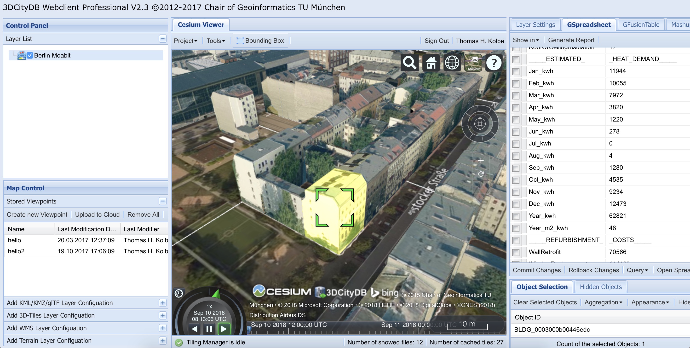
Besides the Open Source 3DCityDB-Web-Map-Client as described in Section 6 the Chair of Geoinformatics has also developed a “Professional Version” of the interactive 3D web client. This version links 3D visualization models exported in KML/glTF from 3DCityDB with table data exported using the 3DCityDB Spreadsheet Generator and allows viewing, editing, and querying objects and their thematic data (cf. [HeNK2012]; [YSKK2012]; [ChYK2015]). The configuration of a 3D webclient project (information about each layer, thematic data, preferences, spatial bookmarks) is also stored in the Cloud as a Google Spreadsheet. The following image shows a screenshot of a tool created by TUM for the Energy Atlas Berlin that is based on the “3D Webclient Professional”. It estimates building energy demands based on the German standard DIN 18599 and the 3D building models in CityGML and allows to interactively explore retrofitting potentials for single or sets of buildings (cf. [KaKo2014]). Thematic data are stored in Google Spreadsheets, where spreadsheet formulas are employed to implement ad-hoc computation of energy values and their changes according to retrofit measures. Also the costs of the retrofitting measures are estimated for each building individually.
8.2.2. Research Projects in which 3DCityDB is being used
Semantic 3D city modeling, city system modeling, and indoor navigation are major research fields of the Chair of Geoinformatics at TUM. We have been driving the international development of CityGML and IndoorGML within the OGC. We are partners in and/or coordinators of projects on Smart Cities, Sustainable Urban Development, and Strategic Energy Planning funded by the Climate-KIC of the European Institute of Innovation & Technology (EIT). Projects using 3DCityDB are: Energy Atlas Berlin, Neighborhood Demonstrators, Smart Sustainable Districts, Modeling City Systems, and Smart District Data Infrastructure. 3DCityDB has also been used in the OGC Future Cities Pilot, and ’ 3D Tracks- Collaborative Subway Track Planning in Multi-Scale 3D City and Building Models’ [BKDS2015] funded by the German Science Foundation (DFG) and was used in projects on deriving 3D DLM from 2D DLM and DTM/DSM [FMWD2018].
8.2.3. Current and future work on 3DCityDB
The team at the Chair of Geoinformatics is currently working on the following tools and extensions to 3DCityDB. Most of them will be made available as Open Source software within the 3DCityDB repository as soon as they are finished and tested:
Support of the Dynamizer ADE: Dynamizers extend CityGML to support the representation and exchange of time-varying attribute values for all CityGML feature properties using timeseries. Support in 3DCityDB is facilitated by 1) provision of the Java library for importing and exporting CityGML Dynamizer ADE contents, and 2) provision of a new web service, the so-called InterSensor Service, which will give access to the timeseries data stored in the 3DCityDB according to the OGC Sensor Web Enablement standards.
Update Manager: This tool will provide a check-out / check-in functionality for parts of stored 3D city models for the purpose of editing and updating. It will automatically detect changes made on the previously exported (checked-out) CityGML dataset and create WFS as well as direct database transactions that will update the 3DCityDB contents according to the identified changes (check-in).
Solar potential analysis: This tool computes the solar energy of direct and diffuse irradiation on building walls and roofs. The computation considers shadow casting by buildings, vegetation, a Digital Surface Model and the Digital Terrain Model. The monthly energy and irradiation values as well as the sky view factors are attached as generic attributes to wall and roof surface objects and in aggregated form to buildings. The software is implemented in Java and directly connects to the 3DCityDB. It has been employed to estimate the solar potentials in the official Energy Atlas of the city of Helsinki, Finland.