4.3.2. Calculating/updating bounding boxes
This dialog lets you calculate the 2D bounding box of the city objects stored in the database. The bounding box is useful, for instance, as spatial filter for the different import and export operations of the Importer/Exporter (see documentation of the corresponding operations) or for use in external tools.
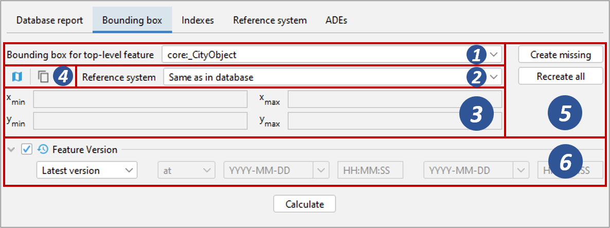
Fig. 4.6 Calculating the bounding box for selected feature types.
First, the top-level feature type needs to be selected for which the bounding box should be calculated [1]. The default option core:_CityObject will operate on all city objects in the database, but you can also restrict the calculation to a specific type such as bldg:Building or wtr:WaterBody. The bounding box can optionally be transformed into a user-defined coordinate reference system [2]. By default, the bounding box is presented in the same reference system as specified for the 3D City Database instance during setup. See Section 3.3 for details on how to define and manage user-defined reference systems.
If your database contains terminated city objects, the optional Feature Version filter [6] lets you define the version of the city objects that should be used for the calculation. The default option Latest version will only operate on non-terminated objects. With Valid version, you can specify that only city objects that were valid at a given timestamp or within a given time range should be considered. If you want the bounding box to be calculated for all city objects independent of whether they are terminated or not, simply disable the filter.
Note
The Feature Version filter works on the CREATION_DATE and TERMINATION_DATE columns of the table CITYOBJECT. More information can be found in Section 4.5.1.
To trigger the calculation, press the Calculate button. The coordinates
of the lower left (xmin, ymin) and upper
right (xmax, ymax) corner of the resulting bounding box are
rendered in the corresponding fields of the dialog [3]. The values are
also copied to the clipboard of your operating system and can therefore
easily be pasted into the import and export dialogs. You can also
manually copy the values to the clipboard by clicking the
 button [4], or by right-clicking on a text field [3] and choosing the
corresponding option from the context menu.
button [4], or by right-clicking on a text field [3] and choosing the
corresponding option from the context menu.
By using the map  button [4],
the calculated bounding box is rendered in a separate 2D map window
for visual inspection as shown below. The usage of this map window is
described in Section 4.8.
button [4],
the calculated bounding box is rendered in a separate 2D map window
for visual inspection as shown below. The usage of this map window is
described in Section 4.8.
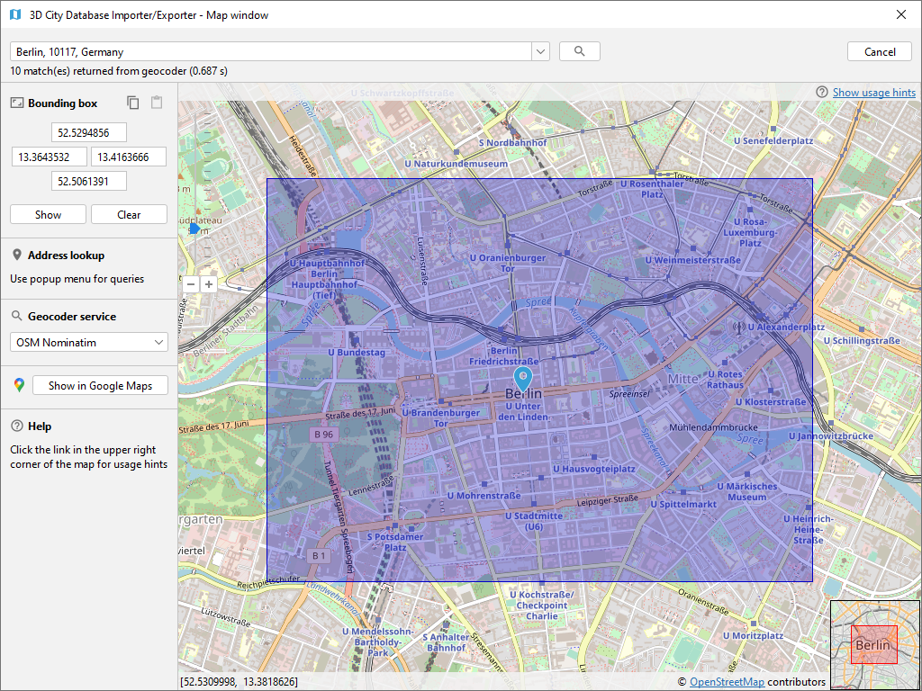
Fig. 4.7 Map window for displaying and choosing bounding boxes. Note that the coordinate values of the bounding box are shown in the upper left component.
The calculation of the bounding box is based on the values stored in the ENVELOPE column of the CITYOBJECT table. If this column is NULL or contains an incorrect value (e.g., in case the value could not correctly be filled during import or the geometry representation of a city object has been changed), then the resulting bounding box will be wrong and subsequent operations might not provide the expected result. To fix the ENVELOPE values in the database, simply let the Importer/Exporter create missing values (i.e., replace NULL values) or recreate all values by clicking on the corresponding buttons [5]. This update process either affects only the city objects of a given feature type or all city objects based on the selection made in [1].
Note
This process directly updates the ENVELOPE column of the affected city objects and might take long to complete since the new values are calculated by evaluating all geometries of the city objects in all LoDs including implicit geometries.