8.3. 3DCityDB @ Virtual City Systems
Virtual City Systems has successfully employed the 3D City Database in customer projects worldwide and also funded its development. With the open source database at the core, Virtual City Systems offers a 3D Spatial Data Infrastructure solution for the management, distribution, maintenance and visualization of massive 3D geo data. Virtual City Systems has a leading role in the development of the 3D City Database and offers a branded version called VC Database to answer customer demands and to provide support and maintenance.
8.3.1. VC Database
The VC Database provides enhanced database functionality as well as plugins for the Importer/Exporter tool that support workflows for maintaining and updating the 3D city model content. Main features are:
- Data continuation and object historiesThe VC Database offers tools and additional database structures to manage updates and multiple versions of city objects in the database as well as to automatically track changes of city objects. Both aspects are relevant in the context of the continuation of city objects and entire city models. The VC Database offers the five operations
Insert,Delete,Terminate,Replace, andUpdatethat enable you to easily keep your 3D city model up-to-date and to get access to previous states of the model. - Integration of additional LoDs against existing city objects in the databaseThis plugin allows for integrating city objects from an external data source with existing city objects stored in the database. The candidate objects are identified with the database objects based on thematic and spatial checks. Therefore, data inconsistency can easily be spotted and analyzed before an import. If an integration is performed, exiting LoDs are replaced and newly introduced LoDs are attached to the existing objects. Moreover, appearance information can be integrated without replacing the geometry.
- Deletion and termination of city objectsThe VC Database provides a user-friendly Importer/Exporter plugin for deleting and terminating city objects using spatial and thematic filter criteria as well as delete lists.
- Transactional Web Feature ServiceCustomers of the VC Database already benefit from an OGC-compliant WFS 2.0 implementation that supports transactions as well as comprehensive spatial and thematic queries using the OGC Filter Encoding standard.
The VC Database is fully compliant with the 3D City Database. If features developed for the VC Database have gained enough maturity, Virtual City Systems will introduce them to the open source 3D City Database project (e.g. the WFS interface).
8.3.2. VC Suite – The Digital Geo-Twin Platform
The VC Suite is a modular 3D Spatial Data Infrastructure solution to store, manage, distribute and visualize 3D geo data. Core components are the VC Database and its OGC WFS interface for accessing and editing the data, the VC Warehouse, a data exchange solution running on FME technology that enables users to export 3D city model content from the VC Database into various industry GIS and CAD formats, and the web-based authoring tool VC Publisher for creating high-performance 3D web maps. Based on the Open Source 3D City Database, the VC Suite allows for building a 3D SDI platform for Digital Geo-Twins based on open standards and interfaces.
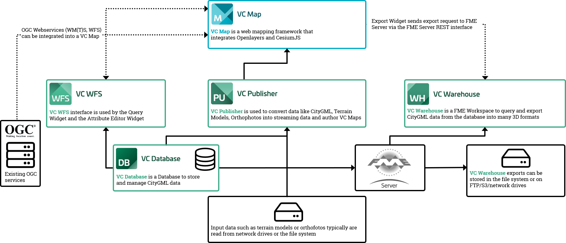
Fig. 8.1 Components of the VC Suite.
Our VC Map web mapping technology offers enhanced GIS functionality beyond pure visualization such as measurements, real-time shadows, viewshed analysis, WFS-based thematic and spatial queries, POI integration, data exports through a VC Warehouse interface, and integration of external data services and sources (e.g., WMS, WFS, GeoJSON, vector tiles) as well as meshes, point clouds and oblique imagery. The 3D web maps are based on the Cesium WebGL virtual globe and therefore can be displayed on modern web browsers and mobile devices such as tablets and smartphones without the need for additional plugins.
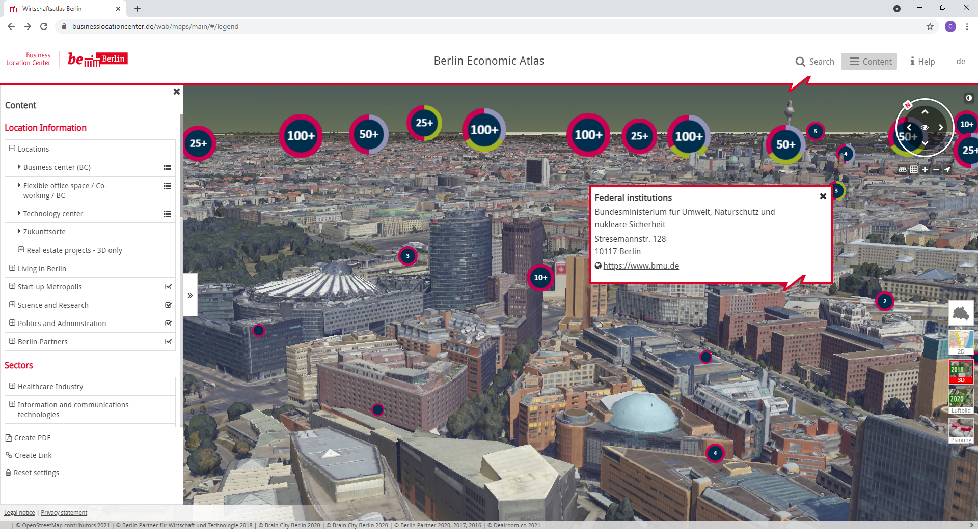
Fig. 8.2 The Berlin 3D City Model is managed based on our VC Suite. The Berlin Economic atlas shown above is a VC Map application that displays the entire city model and combines the 3D objects with business and POI information, see https://www.businesslocationcenter.de/wab/maps/main/#/.