2.7.3.10. Digital Terrain Model
A tuple in the table RELIEF_FEATURE represents a complex relief object, which consists of different relief components. It has an attribute LOD that describes the affiliation of the relief object to a certain level of detail (LoD) of the city model. The individual components of a complex relief object are stored in the tables BREAKLINE_RELIEF, TIN_RELIEF, MASSPOINT_RELIEF and RASTER_RELIEF. Every relief component has an attribute LOD that describes the affiliation to a certain level of detail (resolution, accuracy). However, individual components of a complex relief object may belong to different LoD and may be heterogeneous, i.e. a mixture of TINs, grids and mass points. Optionally, the geometrical separation between the individual relief components of a complex relief object can be realized via polygons (attribute EXTENT), which specify the validity area of the relief component. Every relief component has an attribute NAME that is used for naming of the component. The relief as well as every relief component are derived from CITYOBJECT and receive the same ID as the CityObject. Table RELIEF_FEAT_TO_REL_COMP represents the interrelationship between relief features and relief components.
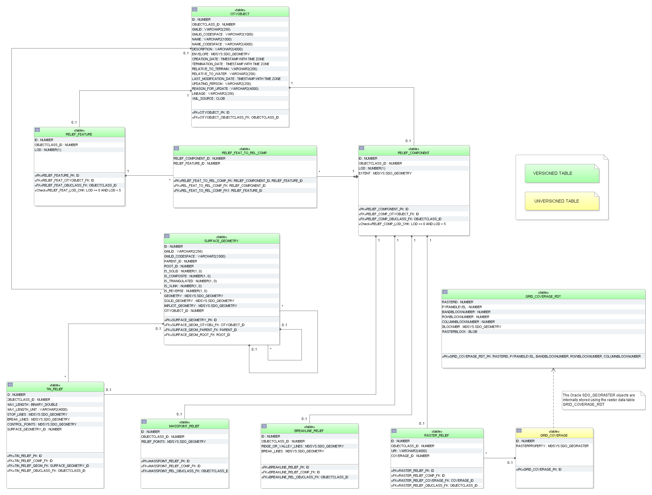
Fig. 2.50 Digital Terrain Model database schema
A raster relief is the only feature in CityGML that can be described by a grid coverage. Corresponding database types are SDO_GEORASTER in Oracle Spatial 11g or higher (not available in Oracle Locator) and RASTER in PostGIS 2.0 or higher. In Oracle for each table that stores SDO_GEORASTER an additional table of type SDO_RASTER is mandatory (raster data table = RDT). It stores the metadata of the SDO_GEORASTER.
In case of that a grid representation is introduced to other features in CityGML in the future, numerous RDT tables would be created when storing grids along with the thematic tables. Thus, a central table called GRID_COVERAGE is used to register all grid data and to prevent numerous additional tables in the 3DCityDB schema. This concept is analogue to the storage of surface-based geometry whereas SURFACE_GEOMETRY is the central table.
Since Oracle Spatial 11g the SDO_GEORASTER type supports Oracle Workspace Manager (cf. [Murr2010]). Therefore, the table GRD_COVERAGE_RDT can be versioned for history management. However, Oracle Spatial doesn’t allow user to version-enable the tables, where GeoRaster objects are stored. Hence, the table GRID_COVERAGE cannot be versioned using the Oracle Workspace Manager.
Geometry attributes for different relief components are limited to these value domains:
BREAKLINE_RELIEF
- BREAK_LINES and RIDGE_OR_VALLEY_LINES
- Oracle: MultiLine (GTYPE 3006)
- PostGIS: MultiLineString Z
TIN_RELIEF
- STOP_LINES and BREAK_LINES
- Oracle: MultiLine (GTYPE 3006)
- PostGIS: MultiLineString Z
- RELIEF_POINTS
- Oracle: MultiPoint (GTYPE 3001 or 3005)
- PostGIS: MultiPoint Z
- TIN
- TIN triangles could be stored as triangulated surfaces in table SURFACE_GEOMETRY
MASSPOINT_RELIEF
- RELIEF_POINTS
- Oracle: MultiPoint (GTYPE 3001 or 3005)
- PostGIS: MultiPoint Z
RELIEF_COMPONENT
- EXTENT (defines the validity extents of each relief component)
- Oracle: Polygon (GTYPE 3003, ETYPE 1003, SDO_ INTERPRETATION 1 or 3 (optimized rectangle))
- PostGIS: Polygon Z