2.6.4.5. Generic Objects and Attributes
The concept of generic objects and attributes has been introduced to facilitate the storage and exchange of 3D objects, which are not covered by explicitly modelled classes within CityGML or which requires additional attributes. These generic extensions are realised by the class GenericCityObject and the data type genericAttribute (cf. Fig. 2.14).
A GenericCityObject may have the attributes class, function, and usage are specified as gml:CodeType. The class attribute allows an object classification within the thematic area such as bridge, tunnel, pipe, power line, dam, or unknown. The function attribute describes to which thematic area the GenericCityObject belongs (e.g. site, transportation, architecture, energy supply, water supply, unknown etc.). The attribute usage can be used, if the object’s usage differs from its function. Each _CityObject and all thematic subclasses can have an arbitrary number of genericAttributes. Data types may be String, Integer, Double (floating point number), URI (Unified Resource Identifier), Date, and gml:MeasureType. The attribute type is defined by the selection of the particular subclass of _genericAttribute (stringAttribute, intAttribute etc.). In addition, generic attributes can be grouped using the genericAttributeSet class which is derived from _genericAttribute and thus is also realized as generic attribute. Its value is the set of contained generic attributes.
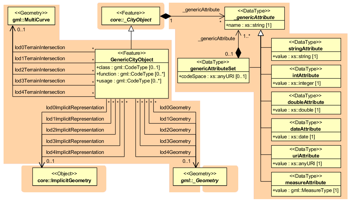
Fig. 2.14 GenericCityObject model
The geometry of a GenericCityObject can either be an explicit GML3 geometry or an ImplicitGeometry. In the case of an explicit geometry, the object can have only one geometry for each LoD, which may be an arbitrary 3D GML geometry object (class _Geometry, which is the base class of all GML geometries, lodXGeometry, X in 0…4). Absolute coordinates according to the reference system of the city model must be given for the explicit geometry. In the case of an ImplicitGeometry, a reference point (anchor point) of the object and optionally a transformation matrix must be given. In order to compute the actual location of the object, the transformation of the local coordinates into the reference system of the city model must be processed and the anchor point coordinates must be added. The shape of an ImplicitGeometry can be given as an external resource with a proprietary format, e.g. a VRML or DXF file from a local file system or an external web service. Alternatively, the shape can be specified as a 3D GML3 geometry with local Cartesian coordinates using the property relativeGeometry.
In order to specify the exact intersection of the DTM with the 3D geometry of a GenericCityObject, the latter can have TerrainIntersectionCurves for every LoD. This is important for 3D visualization but also for certain applications like driving simulators. For example, if a city wall (e.g., the Great Wall of China) should be represented as a GenericCityObject, a smooth transition between the DTM and the road on the city wall would have to be ensured (in order to avoid unrealistic bumps).