2.6.4.11. WaterBodies Model
The water bodies model represents the thematic aspects and 3D geometry of rivers, canals, lakes, and basins. In LoD 2-4 water bodies are bounded by distinct thematic surfaces. These surfaces are the obligatory WaterSurface, defined as the boundary between water and air, the optional WaterGroundSurface, defined as the boundary between water and underground (e.g. DTM or floor of a 3D basin object), and zero or more WaterClosureSurfaces, defined as virtual boundaries between different water bodies or between water and the end of a modelled region (cf. Fig. 2.25). A dynamic element may be the WaterSurface to represent temporarily changing situations of tidal flats.
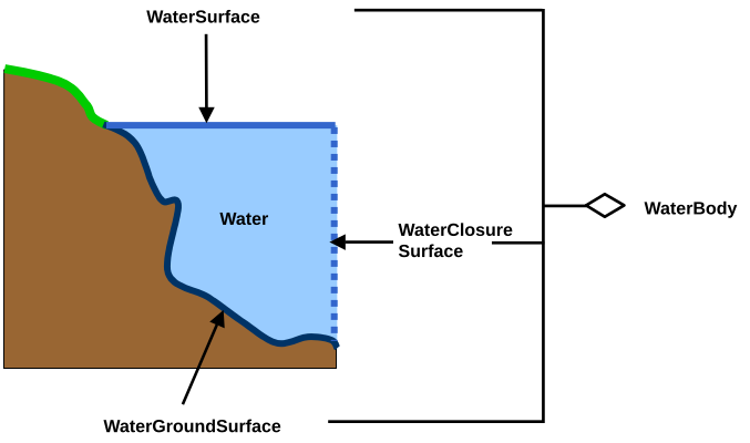
Fig. 2.25 Definition of waterbody attributes (from: [GKNH2012])
Each WaterBody object may have the attributes class (e.g. lake, river, or fountain), function (e.g. national waterway or public swimming) and usage (e.g. navigable) referencing to external code lists. Since the attributes usage and function may be used multiple times, storing them in only one string requires a unique delimiter.
WaterBody is a subclass of the root class _CityObject. The geometrical representation of the WaterBody varies for different levels of detail. The WaterBody can be differentiated semantically by the class _WaterBoundarySurface. A _WaterBoundarySurface is a part of the water body’s exterior shell with a special function like WaterSurface, WaterGroundSurface or WaterClosureSurface. As with any _CityObject, WaterBody objects as well as WaterSurface, WaterGroundSurface, and WaterClosureSurface objects may be assigned ExternalReferences and GenericAttributes.
Both LoD0 and LoD1 represent a low level of illustration and high grade of generalisation. Here the rivers are modelled as MultiCurve geometry and brooks are omitted. Seas, oceans, and lakes with significant extent are represented as MultiSurfaces. (cf. Fig. 2.26)
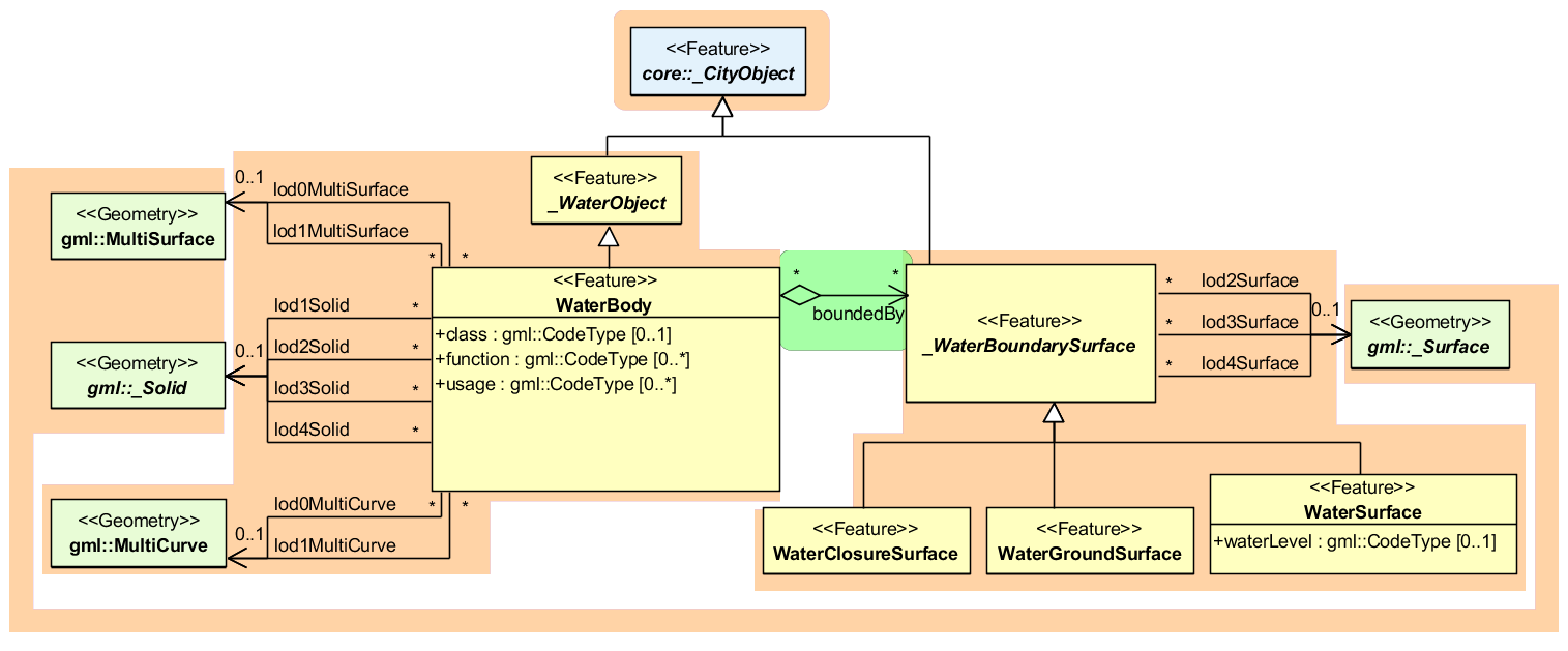
Fig. 2.26 Waterbody model
Starting from LoD1, water bodies may also be modelled as volumes filled with water, represented by Solids. If a water body is represented by a Solid in LoD2 or higher, the surface geometries of the corresponding thematic WaterClosureSurface, WaterGroundSurface, and WaterSurface objects must coincide with the exterior shell of the Solid. This can be ensured, if for one LoD X the respective lodXSurface elements (where X is between 2 and 4) of WaterClosureSurface, WaterGroundSurface, and WaterSurface reference the corresponding polygons (using XLink) within the CompositeSurface that defines the exterior shell of the Solid. Furthermore, every _WaterBoundarySurface must have at least one associated surface geometry attached.
The water body model implicitly includes the concept of TerrainIntersectionCurves (TIC), e.g. to specify the exact intersection of the DTM with the 3D geometry of a WaterBody or to adjust a WaterBody or WaterSurface to the surrounding DTM. The rings defining the WaterSurface polygons implicitly delineate the intersection of the water body with the terrain or basin.