3.4. Exporting to CityGML
3D city model content stored in a 3D City Database instance can be fully or partially exported as CityGML datasets. The CityGML export is available on the Export tab of the operations window as depicted in the following figure.
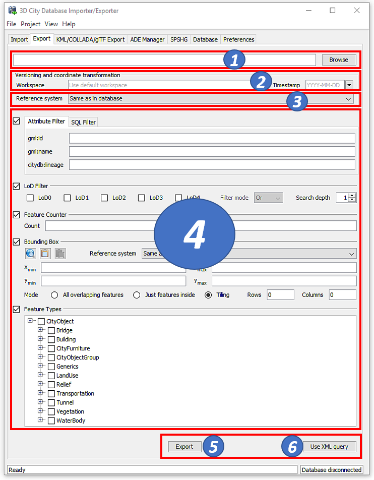
Fig. 3.14 The CityGML export dialog.
Output file selection. At the top of the export dialog, the folder and filename of the target CityGML dataset must be specified [1]. You can either manually enter the target file or open a file selection dialog via the Browse button.
The exporter supports the following file formats for writing CityGML datasets: 1) regular XML files (*.gml, *.xml), 2) GZIP compressed XML files (*.gz, *.gzip), and 3) ZIP archives (*.zip). Simply make sure to add the file extension of the file format of your choice to the name of the target file in [1]. When choosing ZIP as target format, then all additional files such as texture images are also written into the ZIP container per default.
The export operation supports tiled exports, which typically results in multiple datasets being written to the file system. Nevertheless, also for tiled exports, only a single target file must be specified. More details on tiled exports are provided below and in Section 3.6.2.2.
Workspace selection. If the 3D City Database instance is version-enabled (Oracle only), the name of the workspace and the timestamp from which the data shall be exported can be specified [2]. If no workspace is provided, the LIVE workspace is used by default.
Coordinate transformation. In general, coordinate values of geometry objects are associated with the coordinate reference system defined for the 3D City Database instance during setup and are exported “as is” from the database. The export operation allows a user to apply a coordinate transformation to another reference system during export. The target coordinate reference system is chosen from the corresponding drop-down list [3]. This list can be augmented with user-defined reference systems (cf. Section 3.6.4 for more details). When picking the entry “Same as in database”, no transformation will be applied (default behavior).
Simple export filters. Similar to the import process, the export operation supports thematic and spatial filter criteria to restrict exports to subsets of the 3D city model content. The checkboxes on the left side of the export dialog let you choose between an attribute filter, an SQL filter, an LoD filter, a feature counter filter, a spatial bounding box filter and a feature type filter [4]. If more than one filter is chosen, the filter criteria are combined in a logical AND operation. If no checkbox is enabled, no filter criteria are applied and thus all CityGML features contained in the database will be exported.
- Attribute filter: This filter lets you define values for the attributes gml:id, gml:name and citydb:lineage, which must be matched by city objects to be exported. More than one gml:id can be provided in a comma-separated list. Multiple gml:name or citydb:lineage values are not supported though.
- SQL filter: The attribute filter only operates on predefined attributes (see above). To overcome this limitation, you can alternatively choose the SQL Filter tab and enter an arbitrary SELECT statement into the input field. The query must return a list of database ids of the city objects to be exported (i.e., references to the column ID of the table CITYOBJECT). The SQL filter is very powerful as you can access every column of every table in the 3DCityDB and make use of all functions and operations offered by the underlying database system to define your filter. More information about the SQL filter is provided in chapter Section 3.4.1.
- LoD filter: This filter allows for exporting only specific LoDs of the city objects. The LoD selection can be either AND or OR combined. City objects not having a spatial representation in one (OR) or all (AND) of the selected LoDs will not be exported. The search depth parameter specifies how many levels of nested city objects shall be considered when searching for matching LoD representations.
- Counter filter: The feature counter filter limits the number of explicitly exported top-level features. Simply enter the number of features into the count field [4]. The start index parameter indicates the index within the result set from which the export shall begin. The index starts with 0. The parameters can be used together or individually.
- Bounding box filter: The bounding box filter takes the same parameters as on the Import tab. It is evaluated against the ENVELOPE column of the CITYOBJECT table. The user can choose whether the bounding box of top-level features only needs to overlap with or must be strictly inside the filter geometry to satisfy the filter. Alternatively, the export can be tiled by splitting the bounding box into a regular grid. The number of rows and columns can be defined by the user. Each tile of this grid is exported into its own file. To make sure that every city object is assigned to one tile only, the center point of its envelope is checked to be either inside or on the left or top border of the tile.
- Feature type filter: With the feature types filter, you can restrict the export to one or more features types by enabling the corresponding checkboxes. Only features of the chosen type(s) will be exported.
When exporting 3D city model content to a single CityGML file, the file size may quickly grow. Although the Importer/Exporter supports writing files of arbitrary size (only limited by the file system of the operating system), such files might become too big to be processed by other applications. A bounding box filter with tiling enabled is useful in this case because the contents of each tile are written to separate and thus smaller files. The output files are put into subfolders, and the names of both the subfolders and the output files can be augmented with tile-specific suffixes (see the tiling options of the export preferences in chapter Section 3.6.2.2).
Note
Both the gml:name and the citydb:lineage filter internally use an SQL LIKE operator and wildcards for identifying matches. For example, if you provide the string “castle” as gml:name, this will be translated to “LIKE ‘%castle%’” in the SQL query.
Note
When choosing a spatial bounding filter, make sure that spatial indexes are enabled (use the index operation on the Database tab to check the status of indexes, cf. Section 3.2.2).
Note
If the entire 3D city model stored in the 3DCityDB instance shall be exported with tiling enabled, then a bounding box spanning the overall area of the model must be provided. This bounding box can be easily calculated on the Database tab (cf. Section 3.2.2).
Note
Using the center point of the envelope as criterion for a tiled export has a side-effect when tiling is combined with the counter filter: the number of city objects on the tile can be less than the number of city objects returned by the database query because the tile check happens after the objects have been queried. Therefore, the counter filter only sets a possible maximum number in this filter combination. This is a correct behavior, so the Importer/Exporter will not report any errors.
Note
The feature type filter in general behaves like for the CityGML import. However, regarding city object groups the following rules apply:
- If only the feature type CityObjectGroup is checked, then all city object groups and all their group members (independent of their feature type) are exported.
- If further feature types are selected in addition to CityObjectGroup, then only group members matching those feature types are exported. Of course, all features that match the type selection but are not group members are also exported.
Advanced XML export query. The export can also be controlled through a more advanced query expression. In addition to the simple filter capabilities explained above, a query expression offers logical operators (AND, OR, NOT) that combine thematic and spatial filters to complex conditions. Moreover, it allows for defining projections on the properties of the exported city objects and provides a filter for different appearance themes. Operators like the LoD filter or tiling are, of course, also available for query expressions.
Query expressions are encoded in XML using a <query> element. The
query language used has been developed for the purpose of the 3DCityDB
but is strongly inspired by and very similar to the OGC Filter Encoding
2.0 standard and the query expressions used by the OGC Web Feature
Service 2.0 standard.
To enter an XML-based query expression, click on the Use XML query button [6] at the bottom right of the export dialog (cf. Fig. 3.14). The simple filter settings dialog will be replaced with an XML input field like shown below.
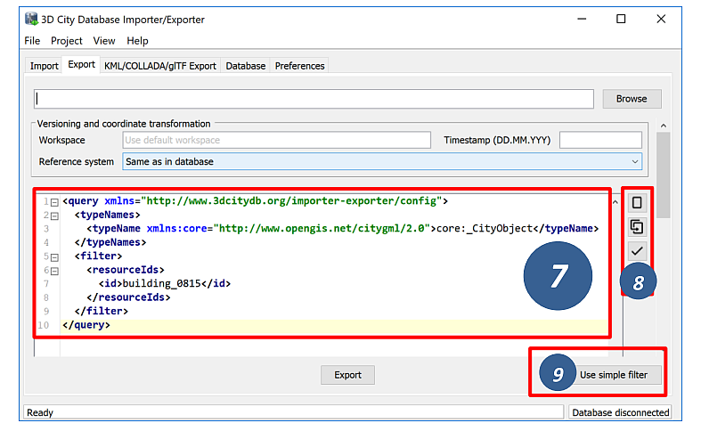
Fig. 3.15 Input field to enter an XML-based query expression for CityGML exports.
The XML query is entered in [7]. This requires knowledge about the structure and the allowed elements of the query language. A documentation of the query language is provided in Section 3.4.2.
The new query button ![]() on the right side of the input field
[8] can be used to create an empty query element that contains all
allowed subelements. The copy query button
on the right side of the input field
[8] can be used to create an empty query element that contains all
allowed subelements. The copy query button ![]() translates all
settings defined on the simple filter dialog (cf. Fig. 3.14) to an XML
query. The results of both actions can therefore be used as starting
point for defining your own query expression. The validate query
button
translates all
settings defined on the simple filter dialog (cf. Fig. 3.14) to an XML
query. The results of both actions can therefore be used as starting
point for defining your own query expression. The validate query
button ![]() [8] performs a validation of the query entered in [7]
and prints the validation report to the console window. Only valid query
expressions are accepted by the export operation. The Use simpe filter
button [9] takes you back to the simple filter dialog.
[8] performs a validation of the query entered in [7]
and prints the validation report to the console window. Only valid query
expressions are accepted by the export operation. The Use simpe filter
button [9] takes you back to the simple filter dialog.
You can also use an external XML editor to write XML query expressions.
External editors might be more comfortable to use and often offer
additional tools like auto completion. The XML Schema definition of the
query language (required for validation and auto completion) can be
exported via “Project Save Project XSD As…” on the main menu of the
Importer/Exporter (cf. Section 3.1). Make sure to use a <query> element
as root element of the query expression in your external XML editor.
Export preferences. In addition to the settings on the Export tab, more fine-grained preference settings affecting the CityGML export are available on the Preferences tab of the operations window. Make sure to check these settings before starting the export process. A full documentation of the export preferences can be found in Section 3.6.2. The following table provides a summary overview.
Preference name
|
Description
|
CityGML version
|
CityGML version to be used for exports.
|
Tiling options
|
More settings for tiled exports. Requires that tiling is enabled on the
bounding box filter.
|
CityObjectGroup
|
Defines whether group members are exported by value or by reference.
|
Address
|
Controls the way in which xAL address fragments are exported from the
database.
|
Appearance
|
Defines whether appearance information is exported.
|
XLinks
|
Controls whether referenced features or geometry objects are exported using
XLinks or as deep copies.
|
XSL transformation
|
Defines one or more XSLT stylesheets that shall be applied to the exported
city objects in the given order before writing them to file.
|
Resources
|
Allocation of computer resources used in the export operation.
|
CityGML export. Having completed all settings, the CityGML data export is triggered with the Export button [5] at the bottom of the dialog (cf. Fig. 3.14). If a database connection has not been established manually beforehand, the currently selected entry on the Database tab is used to connect to the 3D City Database. Progress information is displayed within a separate status window. This status window also offers a Cancel button that lets a user abort the export process. The separate steps of the export process as well as possible error messages are reported to the console window.
3.4.1. SQL queries
The simple filter settings on the Export tab of the Importer/Exporter support user-defined SQL queries. The figure below shows the corresponding SQL input field.
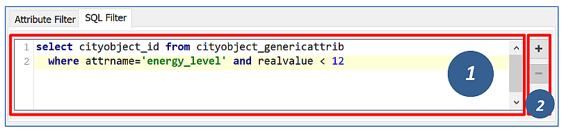
Fig. 3.16 Input field to enter a SQL query for CityGML exports.
The SQL query is entered in [1]. The + and - buttons [2] on the right side of the input field allow for increasing or reducing the size of the input field.
In general, any SELECT statement supported by the underlying database system can be used as SQL filter. The query may operate on all tables and columns of the database instance and may involve any database function or operator. The SQL filter therefore provides a high degree of flexibility for querying content from the 3DCityDB.
The only mandatory restriction is that the SQL query must return a list of ID values of the selected city objects. Put differently, the result set returned by the query may only contain a single column with references to the ID column of the CITYOBJECT table. The name of the result column can be freely chosen, and the result set may contain duplicate ID values. Of course, it must also be ensured that the SELECT statement follows the specification of the database system.
The following example shows a simple query that selects all city objects having a generic attribute of name energy_level with a double value less than 10.
select cityobject_id from cityobject_genericattrib where attrname='energy_level' and realval < 10
The CITYOBJECT_ID column of CITYOBJECT_GENERICATTRIB stores foreign keys to the ID column of CITYOBJECT. The return set therefore fulfills the above requirement.
Note that you do not have to care about the type of the city objects belonging to the ID values in the return set. Since the SQL filter is evaluated together with all other filter settings on the Export tab, the export operation will automatically make sure that only top-level features in accordance with the feature type filter are exported. For example, the above query might return ID values of buildings, city furniture, windows or traffic surfaces. If, however, only buildings have been chosen in the feature type filter, then all ID values in the result set not belonging to buildings will be ignored. This allows writing generic queries that can be reused in different filter combinations. Of course, you may also limit the result set to specific city objects if you like.
The following example illustrates a more complex query selecting all buildings having at least one door object.
select
     t.building_id
from
     thematic_surface t
inner join
     opening_to_them_surface o2t on o2t.thematic_surface_id = t.id
inner join
     opening o on o.id = o2t.opening_id
where
     o.objectclass_id = 39
group by
     t.building_id
having
     count(distinct o.id) > 0
Note
Other statements than SELECT such as UPDATE, DELETE or DDL commands will be rejected and yield an error message. However, in principle, it is possible to create database functions that can be invoked with a SELECT statement and that delete or change content in the database. An example are the DELETE functions offered by the 3DCityDB itself (cf. Section 2.10.8). For this reason, the export operation scans the SQL query for these well-known DELETE functions and refuses to execute it in case one is found. However, similar functions can also be created after setting up the 3DCityDB schema and thus are not known to the export operation a priori. If such functions exist and a user of the Importer/Exporter shall not be able to accidentically invoke them through an SQL query, then it is strongly recommended that the user may only connect to the 3DCityDB instance via a read-only user (cf. Section 2.9.2).
3.4.2. XML query expressions
A query expression is an action that directs the export operation to
search the 3DCityDB for city objects that satisfy some filter expression
encoded within the query. Query expressions are given in XML using a
<query> root element. The XML language used is specific to the
Importer/Exporter and the 3DCityDB but draws many concepts from OGC
standards such as Filter Encoding (FE) 2.0 and Web Feature Service
(WFS) 2.0.
Note
All XML elements of the query language are defined in the XML
namespace http://www.3dcitydb.org/importer-exporter/config. Simply
define this namespace as default namespace on your <query> root element.
A query expression may contain a typeNames parameter, a projection clause, a selection clause, a sorting clause, a counter filter, an LoD filter, an appearance filter, tiling options and a targetSrid attribute for coordinate transformations.
Element
|
Description
|
<typeNames> |
Lists the name of one or more feature types to query (optional).
|
<propertyNames> |
Projection clause that identifies a subset of optional feature properties that shall be
kept or removed in the target dataset (optional).
|
<filter> |
Selection clause that specifies criteria that conditionally select city objects from
the 3DCityDB (optional).
|
<sortBy> |
Sorting clause to specify how city objects shall be ordered in the target
dataset (optional).
|
<limit> |
Limits the number of requested city objects that are exported to the target dataset
(optional).
|
<lod> |
Limits the LoDs of the exported city objects to a given subset (optional).
|
<appearance> |
Limits the appearances of the exported city objects to a given subset (optional).
|
<tiling> |
Defines a tiling scheme for the export (optional).
|
targetSrid
|
Defines a coordinate transformation (optional).
|
3.4.2.1. <typeNames> parameter
The <typeNames> parameter lists the name of one or more feature types to
query from the 3DCityDB. Each name is given as xsd:QName and must use
an official XML namespace from CityGML 2.0 or 1.0. Only top-level
feature types are supported. The CityGML version of the associated XML
namespace determines the CityGML version used for the export dataset.
Namespaces from different CityGML versions shall not be mixed.
The following example shows how to query CityGML 2.0 bridges and buildings:
<query xmlns="http://www.3dcitydb.org/importer-exporter/config">
  <typeNames>
    <typeName xmlns:brid="http://www.opengis.net/citygml/bridge/2.0">brid:Bridge</typeName>
    <typeName xmlns:bldg="http://www.opengis.net/citygml/building/2.0">bldg:Building</typeName>
  </typeNames>
</query>
If you want to query all feature types, then simply use the name
core:_CityObject of the abstract base type in CityGML, or just skip
the <typeNames> parameter.
The following table shows all supported top-level feature types together with their official CityGML XML namespace(s) and their recommended XML prefix.
Feature type
|
XML prefix
|
XML namespace
|
_CityObject
|
core
|
|
Building
|
bldg
|
|
Bridge
|
brid
|
|
Tunnel
|
tun
|
|
TransportationComplex
|
tran
|
|
Road
|
tran
|
|
Track
|
tran
|
|
Road
|
tran
|
|
Square
|
tran
|
|
Railway
|
tran
|
|
CityFurniture
|
frn
|
|
LandUse
|
luse
|
|
WaterBody
|
wtr
|
|
PlantCover
|
veg
|
|
SolitaryVegetationObject
|
veg
|
|
ReliefFeature
|
dem
|
|
GenericCityObject
|
gen
|
|
CityObjectGroup
|
grp
|
In order to simplify typing the <typeNames> parameter, you can skip the
namespace declaration from the type names. The Importer/Exporter will
then assume the corresponding CityGML 2.0 namespace, but only if you use
the recommended XML prefix from the table above. The listing below
exemplifies how to use this simplification to query all city furniture
objects from the 3DCityDB.
<query>
  <typeNames>
    <typeName>frn:CityFurniture</typeName>
  </typeNames>
</query>
3.4.2.2. <propertyNames> projection clause
The <propertyNames> parameter identifies a subset of optional feature
properties that shall be kept or removed in the target dataset. Property
projections can be defined for all feature types that are part of the
export, and thus not just for top-level feature types but also for
nested feature types.
The <propertyNames> parameter consists of one ore more <context>
child elements, each of which must define the target feature type through
the typeName attribute. A context then lists the name of one ore more
feature properties and/or generic attributes. The mode attribute
determines the action for these properties: 1) if set to keep, then
only the listed properties are kept in the target dataset, and all other
properties are deleted from the feature (default); 2) if set to
remove, then only the listed properties are deleted from the feature,
and all other properties are kept.
The following listing shows an example in which only the properties bldg:measuredHeight and bldg:lod2Solid shall be exported for bldg:Building features (mode = keep). Note that this implies that all other thematic and spatial properties of buildings are deleted. For bldg:WallSurface features, all properties shall be kept besides the generic measure attribute area (mode = remove).
<query>
  <propertyNames>
    <context typeName="bldg:Building" mode="keep">
      <propertyName>bldg:measuredHeight</propertyName>
      <propertyName>bldg:lod2Solid</propertyName>
    </context>
    <context typeName="bldg:WallSurface" mode="remove">
      <genericAttributeName type="measureAttribute">area</genericAttributeName>
    </context>
  </propertyNames>
</query>
The typeName of the target feature type must be given as xsd:QName.
Like for the <typeNames> parameter, the XML namespace declaration can be
skipped if XML prefixes from Table 3.5
are used. Multiple <context> elements for the same typeName are not allowed.
Each propertyName must reference a valid property of the given feature type. This includes properties that are defined for the feature type or inherited from a parent type in the CityGML schemas, but also properties injected through an ADE. The propertyName is given as xsd:QName. Mandatory properties like gml:id cannot be removed.
Generic attributes are also referenced by their name using a genericAttributeName element. The name is case sensitive and thus must exactly match the name stored in the database. The optional type attribute can be used to more precisely specify the target generic attribute. If type is omitted, then all generic attributes matching the name are kept or removed, independent of their type. If you want to address all generic attributes of a given type but independent of their name, then use a propertyName instead as illustrated below. In this example, all gen:stringAttributes are removed from bldg:Building.
<query>
  <propertyNames>
    <context typeName="bldg:Building" mode="remove">
      <propertyName>gen:stringAttribute</propertyName>
    </context>
  </propertyNames>
</query>
The typeName may also point to an abstract feature type such as bldg:_AbstractBuilding or core:_CityObject. The property projection is then applied to all subtypes and can even be refined on the level of individual subtypes if the value of the mode attribute is identical. If mode differs, then the context of the subtype overrides the context of the (abstract) supertype.
The listing below shows how to remove gml:name and generic attributes of name location from all city objects by defining a projection context for the abstract type core:_CityObject. The projection is refined for bldg:Building by additionally removing bldg:measuredHeight.
<query>
  <propertyNames>
    <context typeName="core:_CityObject" mode="remove">
      <propertyName>gml:name</propertyName>
      <genericAttributeName>location</genericAttributeName>
    </context>
    <context typeName="bldg:Building" mode="remove">
      <propertyName>bldg:measuredHeight</propertyName>
    </context>
  </propertyNames>
</query>
If mode would be switched to keep on the bldg:Building context in the above example, then this would override the core:_CityObject settings for buildings. Thus, buildings would only keep the bldg:measuredHeight property. The core:_CityObject context would, however, still apply to all other city objects besides buildings.
3.4.2.3. <filter> selection clause
The <filter> parameter is used to identify a subset of city objects from
the 3DCityDB whose property values satisfy a set of logically connected
predicates. If the property values of a city object satisfy all the
predicates in a filter, then that city object is part of the export.
Predicates can be expressed both on properties of the top-level feature
types listed by the <typeNames> parameter and on properties of their
nested feature types. If the predicates are not satisfied, then the
entire top-level feature is not exported.
If the <typeNames> parameter lists more than one top-level feature type,
then predicates may only be expressed on properties common to all of
them.
The <filter> parameter supports comparison operators, spatial
operators and logical operators. The meaning of the operators is
identical to the operators defined in the OGC Filter Encoding (FE) 2.0
standard,
but their encoding slightly differs.
Most expressions are formed using a valueReference pointing to a property value and a literal value that is checked against the property value.
3.4.2.3.1. Value references
A value reference is a string that represents a value that is to be evaluated by a predicate. The string can be the name of a property of the feature type or an XML Path Language (XPath) expression that represents the property of a nested feature type or a complex property.
Property names are given as xsd:QName. Examples for valid property names are core:creationDate, bldg:measuredHeight, and tun:lod2MultiSurface.
In cases where a property of a nested feature type or complex property shall be evaluated, the value reference must be encoded using XPath. The XPath expression is to be formulated based on the XML encoding of CityGML. Note that the Importer/Exporter only supports a subset of the full XPath language:
- Only the abbreviated form of the child and attribute axis specifier is supported.
- The context node is the top-level feature type to be exported. In
case two or more top-level feature types are listed by the
<typeNames>parameter, then the context node is their common parent type. - Each step in the path may include an XPath predicate of the form “.=value” or “child=value”. Equality tests can be logically combined using the “and” or “or” operators. Indexes are not supported as XPath predicate.
- The schema-element() function is supported. It takes the xsd:QName of a feature type as parameter. The function selects the given feature type and all its subtypes.
- The last step of the XPath must be a simple thematic attribute or a spatial property. Property elements that contain a nested feature are not allowed as last step.
Assuming that bldg:Building is the top-level feature type to be exported, then the following examples are valid XPath expressions:
gen:stringAttribute/@gen:nameselects the gen:name attribute of the generic string attributes of the buildinggen:stringAttribute[@gen:name=’area’]/gen:valueselects the gen:value of a generic string attribute with the name “area”bldg:boundedBy/bldg:WallSurface/bldg:lod2MultiSurfaceselects the spatial LoD2 representation of the wall surfaces of the buildingbldg:boundedBy/bldg:WallSurface[@gml:id='ID_01' or gml:name='wall']/bldg:opening/bldg:Door/gml:nameselects the gml:name of doors that are associated with wall surfaces having a specific gml:id or gml:namebldg:boundedBy/schema-element(bldg:_BoundarySurface)/core:creationDateselects the core:creationDate attribute of all boundary surfaces of the buildingcore:externalReference[core:informationSystem='http://somewhere.de']/core:externalObject/core:nameselects the core:name of the external object in an external reference to a given information systemgen:genericAttributeSet[@gen:name='energy']/gen:measureAttribute/gen:valueselects the gen:value of all generic measure attributes contained in the generic attribute set named “energy”
Note
CityGML uses the eXtensible Address Language (xAL) to encode addresses of buildings, bridges and tunnels. xAL is very flexible and allows an address to be encoded in different ways, which makes XPath expressions complex to write. For this reason, the Importer/Exporter uses a simple ADE that can be used in XPath expressions to evaluate address elements such as the street or city name. More information is provided in Section 3.4.2.10.
3.4.2.3.2. Literals and geometric values
Literals are explicitly stated values that are evaluated against a valueReference. The type of the literal value must match the type of the referenced value.
If the literal value is a geometric value, the value must be encoded using one of the geometry types offered by the query language. The following geometry types are available:
<envelope><point><lineString><polygon><multiPoint>(list of<point>elements)<multiLineString>(list of<lineString>elements)<multiPolygon>(list of<polygon>elements)
An <envelope> is defined by its <lowerCorner> and <upperCorner> elements
that carry the coordinate values. The coordinates of a <point> are
provided by a <pos> element, whereas <lineString> uses a <posList>
element. A <polygon> can have one <exterior> and zero or more <interior>
rings. Rings are supposed to be closed meaning that the first and the
last coordinate tuple in the list must be identical. Interior rings must
be defined in opposite direction compared to the exterior ring.
The dimension of the points contained in a <posList> as well as in
<exterior> and <interior> rings can be denoted using the dimension
attribute. Valid values are 2 (default) or 3.
Every geometry type offers an optional srid attribute to reference an SRID defined in the underlying database. If srid is present, then the coordinate tuples are assumed to be given in the reference system associated with the corresponding SRID, which is also used in coordinate transformations. If srid is not present, then the coordinate tuples are assumed to be given in the SRID of the 3DCityDB instance.
| 2D bounding box | <envelope>
<lowerCorner>30 10</lowerCorner>
<upperCorner>60 20</upperCorner>
</envelope>
|
| 2D point | <point>
<pos>30 10</pos>
</point>
|
| 2D line string given in SRID 4326 | <lineString srid="4326">
<posList dimension="2">45.67 88.56 55.56 89.44</posList>
</lineString>
|
| 2D polygon with hole | <polygon>
<exterior>35 10 45 45 15 40 10 20 35 10</exterior>
<interior>20 30 35 35 30 20 20 30</interior>
</polygon>
|
3.4.2.3.3. Comparison operators
A comparison operator is used to form expressions that evaluate the mathematical comparison between two arguments. The following binary comparisons are supported:
<propertyIsEqualTo>(=)<propertyIsLessThan>(<)<propertyIsGreaterThan>(>)<propertyIsEqualTo>(=)<propertyIsLessThanOrEqualTo>(<=)<propertyIsGreaterThanOrEqualTo>(>=)<propertyIsNotEqualTo>(<>)
The optional matchCase attribute can be used to specify how string comparisons should be performed. A value of true means that string comparisons shall match case (default), false means caseless.
The following example shows how to export all buildings from the 3DCityDB whose bldg:measuredHeight attribute has a values less than 50.
<query>
<typeNames>
<typeName>bldg:Building</typeName>
</typeNames>
<filter>
<propertyIsLessThan>
<valueReference>bldg:measuredHeight</valueReference>
<literal>50</literal>
</propertyIsLessThan>
</filter>
</query>
Besides these default binary operators, the following additional comparison operators are supported:
<propertyIsLike><propertyIsNull><propertyIsBetween>
The <propertyIsLike> operator expresses a string comparison with pattern
matching. A combination of regular characters, the wildCard character
(default: *), the singleCharacter (default: .), and the
escapeCharacter (default: \) define the pattern. The wildCard
character matches zero or more characters. The singleCharacter matches
exactly one character. The escapeCharacter is used to escape the
meaning of the wildCard, singleCharacter and escapeCharacter
itself. The matchCase attribute is also available for the
<propertyIsLike> operator.
The following example shows how to find all roads whose gml:name contains the string “main”.
<query>
<typeNames>
<typeName>tran:Road</typeName>
</typeNames>
<filter>
<propertyIsLike wildCard="*" singleCharacter="." escapeCharacter="\" matchCase="false">
<valueReference>gml:name</valueReference>
<literal>*main*</literal>
</propertyIsLike>
</filter>
</query>
The <propertyIsNull> operator tests the specified property to see if it
exists for the feature type being evaluated.
The <propertyIsBetween> operator is a compact way of expressing a range
check. The lower and upper boundary values are inclusive. The operator
is used below to find all buildings having between 10 and 20 storeys.
<query>
<typeNames>
<typeName>bldg:Building</typeName>
</typeNames>
<filter>
<propertyIsBetween>
<valueReference>bldg:storeysAboveGround</valueReference>
<lowerBoundary>10</lowerBoundary>
<upperBoundary>20</upperBoundary>
</propertyIsBetween>
</filter>
</query>
3.4.2.3.4. Spatial operators
A spatial operator determines whether its geometric arguments satisfy the stated spatial relationship. The following operators are supported:
<bbox><equals><disjoint><touches><within><overlaps><intersects><contains><dWithin><beyond>
The semantics of the spatial operators are defined in OGC Filter Encoding 2.0, 7.8.3, and in ISO 19125-1:2004, 6.1.14.
The valueReference of the spatial operators must point to a geometric property of the feature type or its nested feature types. If valueReference is omitted, then the gml:boundedBy property is used per default.
The listing below exemplifies how to use the <bbox> operator to find all
city objects whose envelope stored in gml:boundedBy is not disjoint
with the given geometry.
<query>
<filter>
<bbox>
<envelope>
  <lowerCorner>30 10</lowerCorner>
  <upperCorner>60 20</upperCorner>
</envelope>
</bbox>
</filter>
</query>
The following example exports all buildings having a nested bldg:GroundSurface feature whose bldg:lod2MultiSurface property intersects the given 2D polygon.
<query>
  <typeNames>
    <typeName>bldg:Building</typeName>
  </typeNames>
  <filter>
    <intersects>
      <valueReference>bldg:boundedBy/bldg:GroundSurface/bldg:lod2MultiSurface</valueReference>
      <polygon>
        <exterior>35 10 45 45 15 40 10 20 35 10</exterior>
      </polygon>
    </intersects>
  </filter>
</query>
The last example demonstrates how to find all city furniture features whose envelope geometry is within the distance of 80 meters from a given point location. The uom attribute denotes the unit of measure for the distance. If uom is omitted, then the unit is taken from the definition of the associated reference system. If the reference system lacks a unit definition, meter is used as default value.
<query>
  <typeNames>
    <typeName>frn:CityFurniture</typeName>
  </typeNames>
  <filter>
    <dWithin>
      <valueReference>gml:boundedBy</valueReference>
      <point srid="4326">
        <pos>45.67 88.56</pos>
      </point>
      <distance uom="m">80</distance>
    </dWithin>
  </filter>
</query>
3.4.2.3.5. Logical operators
A logical operator can be used to combine one or more conditional
expressions. The logical operator <and> evaluates to true if all the
combined expressions evaluate to true. The operator <or> operator
evaluates to true is any of the combined expressions evaluate to true.
The <not> operator reverses the logical value of an expression. Logical
operators can contain nested logical operators.
The following <and> filter combines a <propertyIsLessThan> comparison
and a spatial <dWithin> operator to find all buildings with a
bldg:measuredHeight less than 50 and within a distance of 80 meters
from a given point location.
<query>
  <typeNames>
    <typeName>bldg:Building</typeName>
  </typeNames>
  <filter>
    <and>
      <propertyIsLessThan>
        <valueReference>bldg:measuredHeight</valueReference>
        <literal>50</literal>
      </propertyIsLessThan>
      <dWithin>
        <valueReference>gml:boundedBy</valueReference>
        <point srid="4326">
          <pos>45.67 88.56</pos>
        </point>
        <distance uom="m">80</distance>
      </dWithin>
    </and>
  </filter>
</query>
3.4.2.3.6. gml:id filter operator
The <resourceIds> operator is a compact way of finding city objects
whose gml:id value is contained in the provided list of <id> elements.
The example below exports all buildings whose gml:id matches one of the values in the list.
<query>
  <typeNames>
    <typeName>bldg:Building</typeName>
  </typeNames>
  <filter>
    <resourceIds>
      <id>ID_01</id>
      <id>ID_02</id>
      <id>ID_03</id>
    </resourceIds>
  </filter>
</query>
3.4.2.3.7. SQL operator
The <sql> operator lets you add arbitrary SQL queries to your filter
expression. It can be combined with all other predicates.
The SQL query is provided in the <select> subelement. It must follow the
same rules as discussed in chapter Section 3.4.1.
Most importantly, the query shall return a list of id values that reference
the ID column of the table CITYOBJECT.
Note that the query is encoded in XML. Thus, characters having special meaning in the XML language must be encoded using entity references. For example, the less-than sign < and greater-than sign > must be encoded as < and > respectively. Instead of using entity references, you can put your SQL string into a CDATA section. The string is then parsed as purely character data.
For example, the following SQL filter expression selects all id values from city objects having a generic attribute called energy_level whose double value is less than 10. The entity reference < must be used here.
<query>
<filter>
<sql>
<select>select cityobject_id from cityobject_genericattrib
where attrname='energy_level' and realval < 10</select>
</sql>
</filter>
</query>
When putting the same query into a CDATA section, the less-than sign must not be replaced with an entity reference.
<query>
  <filter>
    <sql>
      <select>
        <![CDATA[
          select cityobject_id from cityobject_genericattrib
            where attrname='energy_level' and realval < 10
        ]]>
      </select>
    </sql>
  </filter>
</query>
3.4.2.4. <sortBy> sorting clause
The <sortBy> parameter is used to specify a list of property names whose values
should be used to order the set of city objects that satisfy the query. If no
sorting clause is provided, the city objects are exported in an arbitrary order.
The value of the <sortBy> parameter is a list of one or more <sortProperty>
elements, each of which must define a <valueReference> pointing to the property
that shall be used for sorting. Only simple thematic attributes of the requested
top-level feature type or one of its nested feature types are supported. If you specify
multiple <sortProperty> elements, the result set is sorted by the first property
in the list and that sorted result is sorted by the second property, and so on.
For each <sortProperty>, the sort order can be defined using the <sortOrder>
parameter. The value asc indicates an ascending sort (default) and desc indicates
a descending sort.
The following example illustrates how to sort all buildings according to their measured height in descending order.
<query>
  <typeNames>
    <typeName>bldg:Building</typeName>
  </typeNames>
  <sortBy>
    <sortProperty>
      <valueReference>bldg:measuredHeight</valueReference>
      <sortOrder>desc</sortOrder>
    </sortProperty>
  </sortBy>
</query>
3.4.2.5. <limit> parameter
The <limit> parameter limits the number of explicitly requested
top-level city objects in the export dataset. It offers the elements <count>
and <startIndex> that can be used together or individually.
The <count> parameter indicates the total number of city objects that shall
be exported from the set of city objects satisfying the query. And <startIndex>
lets you define the index within this result set from which the export shall begin.
The index starts with 0, which is also the default value.
The query below shows how to export at maximum 10 buildings from the database, even if more buildings satisfy the query.
<query>
  <typeNames>
    <typeName>bldg:Building</typeName>
  </typeNames>
  <limit>
    <count>10</count>
  </limit>
</query>
The following query exports the next 10 buildings by starting with the 11th building in the result set. If the result set contains less buildings, the export dataset will, of course, also contain less buildings.
<query>
  <typeNames>
    <typeName>bldg:Building</typeName>
  </typeNames>
  <limit>
    <count>10</count>
    <startIndex>10</startIndex>
  </limit>
</query>
3.4.2.6. <lods> parameter
The <lods> parameter lists the level of details (LoD) that shall be
exported for the requested feature types.
The LoDs to be exported are given as list of one or more <lod> element having an integer value between 0 and 4. The optional mode attribute specifies whether a feature must have a spatial representation in all of the enumerated LoDs to be exported (mode = and), or whether it is enough that the feature has a spatial representation in at least one LoD from the list (mode = or) (default). If a feature has additional spatial representations in LoDs that are not listed, then these representations are not exported. If a feature does not satisfy the LoD filter condition at all, then it is skipped from the export.
Many feature types in CityGML can have nested sub-features. In such cases, the top-level feature itself is not required to have a spatial property, but the geometry can be modelled for its nested sub-features. For example, a bldg:Building feature does not need to provide an LoD 2 geometry through its own bldg:lod2Solid or bldg:lod2MultiSurface properties. Instead, it can have a list of nested boundary surfaces such as bldg:WallSurface and bldg:RoofSurface features that have own LoD 2 representations. Nevertheless, in this case the bldg:Building is considered to be represented in LoD 2.
To handle these cases, the <lods> parameter offers the optional
searchMode attribute. When set to all, then all nested features are
recursively scanned for having a spatial representation in the provided
list of LoDs. If an LoD representation is found for any (transitive)
sub-feature, then the top-level feature is considered to satisfy the
filter condition. The all mode is, however, expensive because it
requires many joins and sub-queries on the database level. When setting
searchMode to depth instead, you can use the additional
searchDepth attribute to specify the maximum depth to which nested
sub-features are searched for LoD representations.
For example, the following bldg:Building feature has a nested bldg:BuildingInstallation sub-feature and a nested bldg:WallSurface sub-feature. Moreover, the bldg:BuildingInstallation itself has a nested bldg:RoofSurface sub-feature.
<bldg:Building>
  …
  <bldg:outerBuildingInstallation>
    <bldg:BuildingInstallation>
      <bldg:boundedBy>
        <bldg:RoofSurface> … </bldg:RoofSurface>
      </bldg:boundedBy>
    </bldg:BuildingInstallation>
  </bldg:outerBuildingInstallation>
  …
  <bldg:boundedBy>
    <bldg:WallSurface> … </bldg:WallSurface>
  </bldg:boundedBy>
  …
</bldg:Building>
When setting searchDepth to 1 in this example, then not only the bldg:Building but also its nested bldg:BuildingInstallation and bldg:WallSurface are searched for a matching LoD representation, but not the bldg:RoofSurfaces of the bldg:BuildingInstallation. This roof surface is on the nesting depth 2 when counted from the bldg:Building. Thus, searchDepth would have to be set to 2 to also consider this bldg:RoofSurface feature.
Per default, searchMode is set to depth with a searchDepth of 1.
The following listing exemplifies the use of the <lods> parameter. In
this example, all tunnels shall be exported that have either an LoD 2 or
LoD 3 representation. LoD representations are also searched on
sub-features up to a nesting depth of 2.
<query>
  <typeNames>
    <typeName>tun:Tunnel</typeName>
  </typeNames>
  <lods mode="or" searchMode="depth" searchDepth="2">
    <lod>2</lod>
    <lod>3</lod>
  </lods>
</query>
3.4.2.7. <appearance> parameter
The <appearance> parameter filters appearances by their theme. To keep
an appearance in the target dataset, the value of its app:theme
attribute simply has to be enumerated using a <theme> subelement. The
string values must match exactly.
The app:theme attribute in CityGML is optional and thus can be null.
To be able to also express whether appearances having a null theme
should be exported, the <appearance> parameter offers another subelement
<nullTheme>, which is of type Boolean. If set to true, appearances
with a null theme are exported, otherwise not (default).
The following query exports road features and appearances with theme
summer and winter. Since <nullTheme> is set to false, appearances
lacking an app:theme attribute are not exported.
<query>
  <typeNames>
    <typeName>tran:Road</typeName>
  </typeNames>
  <appearance>
    <nullTheme>false</nullTheme>
    <theme>summer</theme>
    <theme>winter</theme>
  </appearance>
</query>
3.4.2.8. <tiling> parameter
The <tiling> parameter allows for exporting the requested top-level
features in tiles. Every tile is exported to its own target file within
a separate subfolder of the export directory.
Like the tiling settings of the simple GUI-based export filter (cf.
chapter Section 3.4),
the <tiling> parameter requires three mandatory inputs:
the <extent> of the geographic region that should be tiled and the
number of <rows> and <columns> into which the region should be evenly
split. The <extent> must be provided as bounding box using a
<lowerCorner> and an <upperCorner> element.
The example below exports all buildings within the provided <extent>
into 2x2 tiles.
<query>
  <typeNames>
    <typeName>bldg:Building</typeName>
  </typeNames>
  <tiling>
    <extent srid="4326">
      <lowerCorner>10.7005978 47.5707931</lowerCorner>
      <upperCorner>10.7093525 47.5767573</upperCorner>
    </extent>
    <rows>2</rows>
    <columns>2</columns>
  </tiling>
</query>
Besides the mandatory input, the optional <cityGMLTilingOptions> parameter
can be used to control the names of the subfolders and tile files, and
whether tile information should be stored as generic attribute. The
following subelements are supported:
<tilePath>Name of subfolder that is created for each tile (default: tile).<tilePathSuffix>Suffix to append to each <tilePath>. Allowed values are row_column (default), xMin_yMin, xMax_yMin, xMin_yMax, xMax_yMax and xMin_yMin_xMax_yMax.<tileNameSuffix>Suffix to append to each tile filename. Allowed values are none (default) and sameAsPath.<includeTileAsGenericAttribute>Add a generic attribute named TILE to each city object.<genericAttributeValue>Value for the generic attribute. Allowed values are identical to those for <tilePathSuffix> (default: xMin_yMin_xMax_yMax).
If the <cityGMLTilingOptions> element is not present, then the settings
defined in the export preferences
(cf. Section 3.6.2.2) are used instead.
3.4.2.9. targetSrid attribute
The <query> element offers an optional targetSrid attribute. If
targetSrid is provided, all exported geometries will be
transformed into the target coordinate reference system. The
targetSrid attribute must reference an SRID available in the underlying
database. The transformation is performed using corresponding database functions.
<query targetSrid="25832">
  …
</query>
3.4.2.10. Address information
The 3DCityDB comes with a CityGML ADE that allows a simple use of address information and metadata columns in XML queries. The following table shows the XML namespaces to be used with CityGML version 2.0 respectively 1.0 and the recommended XML prefix of the 3DCityDB ADE.
ADE
|
XML prefix
|
XML namespace
|
3DCityDB ADE
|
citydb
|
Address information. CityGML uses the OASIS xAL standard for the representation of address information. xAL is very flexible in that it supports various address styles that can be XML-encoded in many ways. As a drawback, this flexibility makes it difficult to define a filter on address elements (e.g., the street or the city) using an XPath expression based on xAL. When importing address information into the 3DCityDB, the xAL address fragment is parsed and mapped onto the columns STREET, HOUSE_NUMBER, PO_BOX, ZIP_CODE, CITY, STATE and COUNTRY of the ADDRESS table. Thus, it is much simpler to express filter criteria on these columns.
For this reason, the 3DCityDB ADE injects additional properties into the core:Address feature of CityGML that correspond to the columns of the ADDRESS table. By this means, these properties can be used in filter expressions. The mapping between ADE properties and columns of the ADDRESS table is shown below. Note that the citydb prefix must be associated with the ADE XML namespace (see above). If omitted, the CityGML 2.0 namespace is assumed given that the prefix citydb is used.
ADE property
(injected into core:Address)
|
Data type
|
Column of the ADDRESS table
|
citydb:street
|
xs:string
|
STREET
|
citydb:houseNumber
|
xs:string
|
HOUSE_NUMBER
|
citydb:poBox
|
xs:string
|
PO_BOX
|
citydb:zipCode
|
xs:string
|
ZIP_CODE
|
citydb:city
|
xs:string
|
CITY
|
citydb:state
|
xs:string
|
STATE
|
citydb:country
|
xs:string
|
COUNTRY
|
The following example illustrates how to query all buildings along the street Unter den Linden. It uses the citydb:street ADE property as value reference in the filter expression.
<query>
  <typeNames>
    <typeName>bldg:Building</typeName>
  </typeNames>
  <filter>
    <propertyIsLike wildCard="*" singleCharacter="." escapeCharacter="\" matchCase="true">
      <valueReference>bldg:address/core:Address/citydb:street</valueReference>
      <literal>Unter den Linden*</literal>
    </propertyIsLike>
  </filter>
</query>
3.4.2.11. 3DCityDB metadata
The 3DCityDB stores database-specific metadata with every city object using the columns LAST_MODIFICATION_DATE, UPDATING_PERSON, REASON_FOR_UPDATE and LINEAGE of the CITYOBJECT table. In order to make these metadata properties available in filter expressions, the 3DCityDB ADE injects them into the CityGML core:_CityObject feature.
ADE property
(injected into core:_CityObject)
|
Data type
|
Column of the CITYOBJECT table
|
citydb:lastModificationDate
|
xs:string
|
LAST_MODIFICATION_DATE
|
citydb:updatingPerson
|
xs:string
|
UPDATING_PERSON
|
citydb:reasonForUpdate
|
xs:string
|
REASON_FOR_UPDATE
|
citydb:lineage
|
xs:string
|
LINEAGE
|
The properties can also be used in filter expressions. For instance, the query below fetches all bridges that have been modified in the database after 2018-01-01.
<query>
  <typeNames>
    <typeName>brid:Bridge</typeName>
  </typeNames>
  <filter>
    <propertyIsGreaterThan>
      <valueReference>citydb:lastModificationDate</valueReference>
      <literal>2018-01-01</literal>
    </propertyIsGreaterThan>
  </filter>
</query>
3.4.2.12. Using XML queries in batch processes
The Importer/Exporter offers a Command-Line Interface (CLI) which allows
for embedding the tool in batch processing workflows and third-party
applications (cf. Section 3.8). XML queries can also be used in CityGML
exports that are triggered via this CLI interface. For this purpose, the
XML query has to be copied into the config file that is used for
running the Importer/Exporter. This can be either the default config
file (cf. Section 3.4) or a local file that is passed to the CLI using
the -config command-line parameter.
Each config file must use a <project> root element associated with the
XML namespace http://www.3dcitydb.org/importer-exporter/config. Export
settings are then provided in the <export> subelement. The <query>
element of an XML query expression can simply be copied as child element
of the <export> element. In addition, the useSimpleQuery attribute on
the <export> element has to be set to false.
The listing below shows an excerpt of a config file using an XML export query.
<?xml version="1.0" encoding="UTF-8" standalone="yes"?>
<project xmlns="http://www.3dcitydb.org/importer-exporter/config">
  <database>
    … database connection details go here …
  </database>
  <export useSimpleQuery="false">
    … copy your query here …
    <query>
      <typeNames>
        <typeName>bldg:Building</typeName>
      </typeNames>
    </query>
    … provide more export settings here …
  </export>
</project>